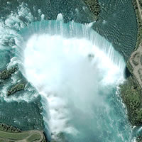
Space Imaging provides some amazing satellite photos to companies for various purposes. They also provide an Image of the Day. Last April they had a beautiful picture of Niagara Falls:

Clouds of mist rise from the bottom of Horseshoe Falls, on the Canadian/United States border, in this one-meter image collected by Space Imaging’s IKONOS satellite. Every second, more than two million liters of water plunges over the Horsehoe Falls segment of Niagara Falls creating one of the world’s largest waterfalls as well as eating away as much as two meters of rock per year.
The image shows the Niagara River, that connects Lake Erie to Lake Ontario, snaking around Goat Island, in the lower left of the full image. Most of the river’s water plummets over the Canadian/Horseshoe Falls, but some diverted water spills over American Falls and Bridal Veil Falls downstream. The image was acquired August 2, 2004.
Compare this photo to the older one I just posted about, and you’ll see a lot of changes! The Space Imaging photo is essentially the same one as the NASA one I posted about last August (the NASA one is huge and has lots more detail).
The Space Imaging site has 4 different versions of the picture. Check it out!